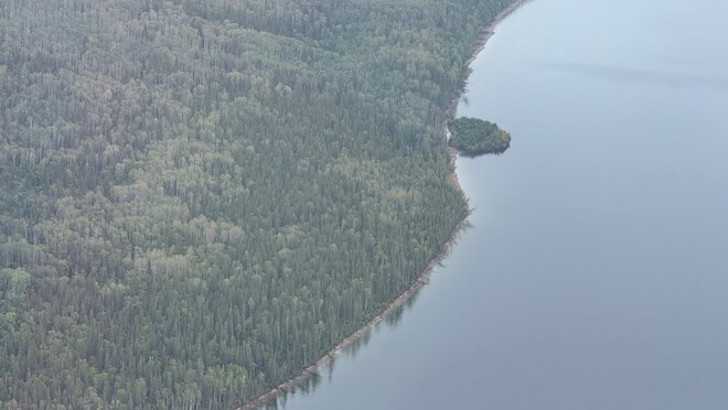

Update: we found the island.
— BC Hydro (@bchydro) September 2, 2026
After briefly becoming one of Canada's most famous islands and making international headlines, the floating island on Williston Reservoir has been found.
Turns out it wasn't missing. Just drifting. All told, it travelled about 30 km in 15 days… pic.twitter.com/h1GSvEcV25
MACKENZIE, B.C.: After briefly becoming one of Canada's most famous islands, the floating island on Williston Reservoir has been found.
The island, which captured international attention after it appeared near Finlay Bay and then seemingly vanished, has been located through a combination of satellite imagery, observations from small aircraft and reports from boaters.
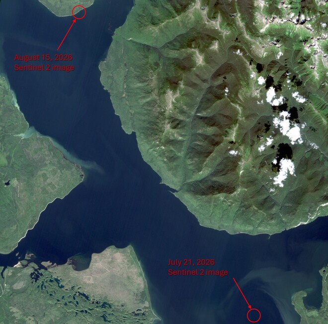
The floating vegetated island has come to rest against the shoreline on the Ospika Arm of Williston Reservoir, approximately 30 kilometres northwest of where it was first discovered near Finlay Bay and farther away from the W.A.C. Bennett Dam. BC Hydro does not expect any operational impacts from the island.
"When we first received photos and video of a floating island covered in trees, we weren't entirely convinced," said BC Hydro Community Relations Manager Bob Gammer. "In the age of AI, it's important to verify unusual reports before drawing conclusions. Once we confirmed the island through satellite imagery and other observations, it quickly captured the imagination of the public and the media and sparked interest among scientists studying how floating vegetated islands form and move."
BC Hydro was first made aware of the island on August 13 after receiving photos and video believed to have been taken on or around July 21. The island, last seen west of Finlay Bay, then disappeared from view and quickly sparked worldwide curiosity, generating headlines from the BBC and The New York Times to TMZ and National Geographic.
The mystery was solved on August 31 when BC Hydro confirmed the island's location using satellite imagery dated August 15. Based on available information, the island drifted approximately 30 kilometres over 15 days before settling along the shoreline in its current location.
The island appears intact and is estimated to be about 70 metres wide and 140 metres long, about the size of two football fields, with established vegetation growing on its surface.
While floating vegetated islands of this size are uncommon, they can occur in large reservoirs. One possible explanation is the island formed from logs and woody debris that accumulated in a sheltered area over many years. As the material gradually decomposed, vegetation may have taken root, creating a stable mass of interconnected debris and plant growth.
The island has also attracted interest from geologists, ecologists and other researchers interested in how floating vegetated islands form and move. While questions remain about exactly how the island formed, observations collected to date are helping improve understanding of this unusual natural phenomenon.
While people are welcome to approach the island by boat or drone to take photos, BC Hydro is asking everyone to stay off the island itself. The island is made up of logs and decaying woody debris, making it unstable and unsafe to land on or climb onto.
"Finding the island has answered one question, but it has raised several others," said Gammer. "While we're pleased to have confirmed the island's location, there is still more to learn about how it formed and how it came to drift across the reservoir. We'll continue monitoring the island and learning more about its origins and movement as the story unfolds. Stay tuned."
Quick facts
Island at a glance
- The floating island is estimated to be approximately 140 metres long and 70 metres wide.
- The island covers roughly 9,800 square metres, or about the size of two football fields.
- The island is currently located along the shoreline of the Ospika Arm of Williston Reservoir.
- The island is approximately 30 kilometres northwest of its original documented location near Finlay Bay.
- The island is now farther from the W.A.C. Bennett Dam than when it was first identified.
Timeline
- July 21, 2026: Satellite imagery from this date was first used (in August) to confirm the island’s existence and location west of Finlay Bay.
- Aug. 13, 2026: BC Hydro receives reports, photos and video of the island from local boaters.
- Mid-August 2026: The island disappears from public view, prompting efforts to determine its location.
- Aug. 15, 2026: The island is captured in satellite imagery near the Ospika Arm.
- Aug. 31, 2026: After reviewing available satellite imagery (dated August 15) and other observations, BC Hydro confirms the island's location along the Ospika Arm, approximately 30 kilometres northwest of where it was first documented.
- Sept. 2, 2026: BC Hydro provides an update after locating the island.
Note: Satellite imagery is not available in real time and may only become available for analysis days or weeks after it is captured.
Williston Reservoir backgrounder
- Williston Reservoir is located in northeastern British Columbia, approximately 300 kilometres north of Prince George and near the community of Mackenzie.
- It’s the largest reservoir in British Columbia and the seventh largest reservoir in the world by volume.
- Created by the construction of the W.A.C. Bennett Dam on the Peace River, the reservoir began filling in 1968.
- The reservoir covers approximately 1,773 square kilometres at full pool.