Wildfire
Wildfire standard notice
- Box Color
- bg-quartz
- Header
- Area notices
- Description
-
This site is now open.
Wildfire standard notice
This site is now open.
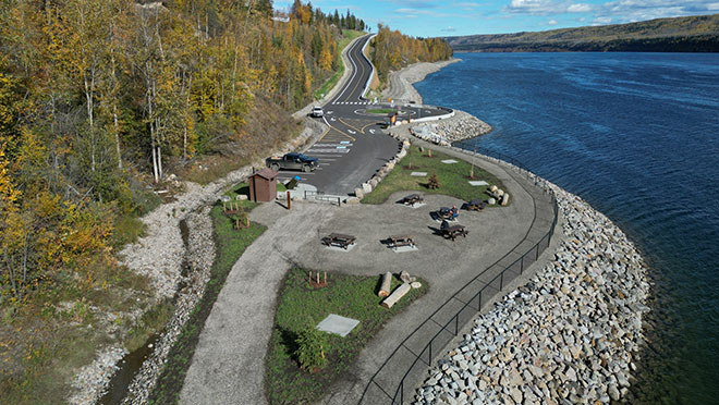
Located at the bottom of D.A. Thomas Road in Hudson's Hope adjacent to Nááchę Mege (formerly Site C reservoir), the D.A. Thomas recreation area includes a picnic site, access to a walking trail, and a floating dock providing kayak and canoe access to Nááchę Mege. Developed as part of BC Hydro’s Site C community investment program under the Site C Clean Energy Project, the recreation area is located on the traditional territory of Treaty 8 First Nations.
The D.A. Thomas recreation area is located in Hudson's Hope, B.C., at the bottom of D.A. Thomas Road. Use this map link for directions.
The D.A. Thomas recreation area is owned and maintained by BC Hydro. Walking trails along the berm are maintained by the District of Hudson's Hope.
Facilities include:
Please exercise caution near the rocky berm, especially during winter conditions.
The Nááchę Mege Reservoir map [PDF, 24 MB] has been prepared to support safe recreational vessel use on the reservoir. While reasonable efforts have been made to depict bathymetry, navigation hazards, and other features relevant to vessel operators, the reservoir is a managed and dynamic environment. Water levels, shoreline conditions, debris, and hazards may change due to operational, environmental, or weather-related factors. This map is not an official nautical chart and is not a substitute for prudent seamanship, on-site observation, official notices, or compliance with local regulations, posted signage, and navigation aids.
Users remain responsible for assessing conditions and navigating safely at all times.
All persons intending to operate a boat on the reservoir should always:
Extreme caution, awareness, and appreciation of hazards are essential for safe boating on Nááchę Mege.
The banks of the reservoir are easily eroded and subject to sloughing from reservoir actions. If wave action is severe and you need to reach shore, it may be difficult to make a safe landing due to cliffs, unstable banks and/or floating or submerged debris along the shoreline.
The nearby shoreline protection berm is a large barrier made of rocks, gravel, and other materials designed to reinforce and protect the shoreline from potential erosion from the reservoir. A public walking trail is located along this berm. Use caution when walking here, especially during winter conditions.