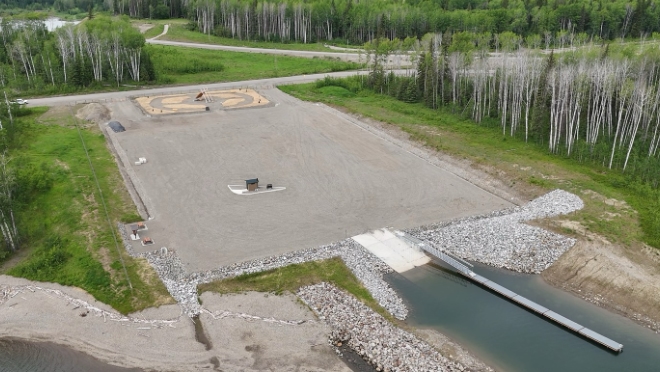
Located just outside Hudson’s Hope, our Lynx Creek (Nǫdaa Saahgae) boat launch provides boaters and anglers with access to Nááchę Mege (formerly Site C reservoir). The boat launch is open seasonally from May to October. The site also includes picnic tables and a pit toilet for public use.
Lynx Creek boat launch
Where it is and things to do
The Lynx Creek boat launch is approximately 6 km to the east of Hudson’s Hope, B.C. and can be accessed via Highway 29. Use this Google Map link for directions.
Nǫdaa Saahgae is a cultural and historical gathering place, where First Nations have come together for generations.
The Lynx Creek boat launch is owned and maintained by BC Hydro.
Facilities include:
- Concrete ramp suitable for lake and jet boats
- Seasonal floating dock
- Pit toilet and picnic tables
- Information kiosk and cultural lean-to
- Gravel parking area
Boating and other safety information
The Nááchę Mege Reservoir map [PDF, 24 MB] has been prepared to support safe recreational vessel use on the reservoir. While reasonable efforts have been made to depict bathymetry, navigation hazards, and other features relevant to vessel operators, the reservoir is a managed and dynamic environment. Water levels, shoreline conditions, debris, and hazards may change due to operational, environmental, or weather-related factors. This map is not an official nautical chart and is not a substitute for prudent seamanship, on-site observation, official notices, or compliance with local regulations, posted signage, and navigation aids.
Users remain responsible for assessing conditions and navigating safely at all times.
All persons intending to operate a boat on the reservoir should always:
- Obey all boater safety laws, which include carrying emergency equipment and wearing life jackets.
- Inform others of your destination and when you plan to return.
- Observe all warning signs and stay well away from BC Hydro's dams and structures.
- Use extreme caution and be aware of hazards when boating on Nááchę Mege.
The banks of the reservoir are easily eroded and subject to sloughing from reservoir actions. If waves are severe and you need to reach shore, it may be difficult to make a safe landing due to cliffs, unstable banks and floating or submerged debris along the shoreline.